NORTHAMPTON CASTLE
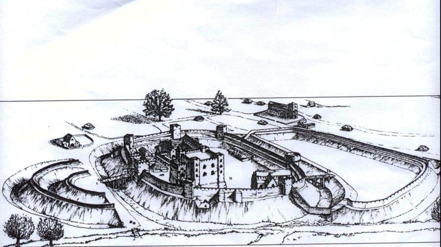
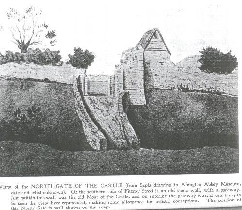
The area of the Boroughs was at the heart of medieval Northampton. The Norman castle built by Simon de Senlis occupied land near the river in the south east of the Boroughs. The great north gate of the Castle faced onto Fitzroy Street and parts of it remained in the Victorian period (see image below)
THE BOROUGHS 1610
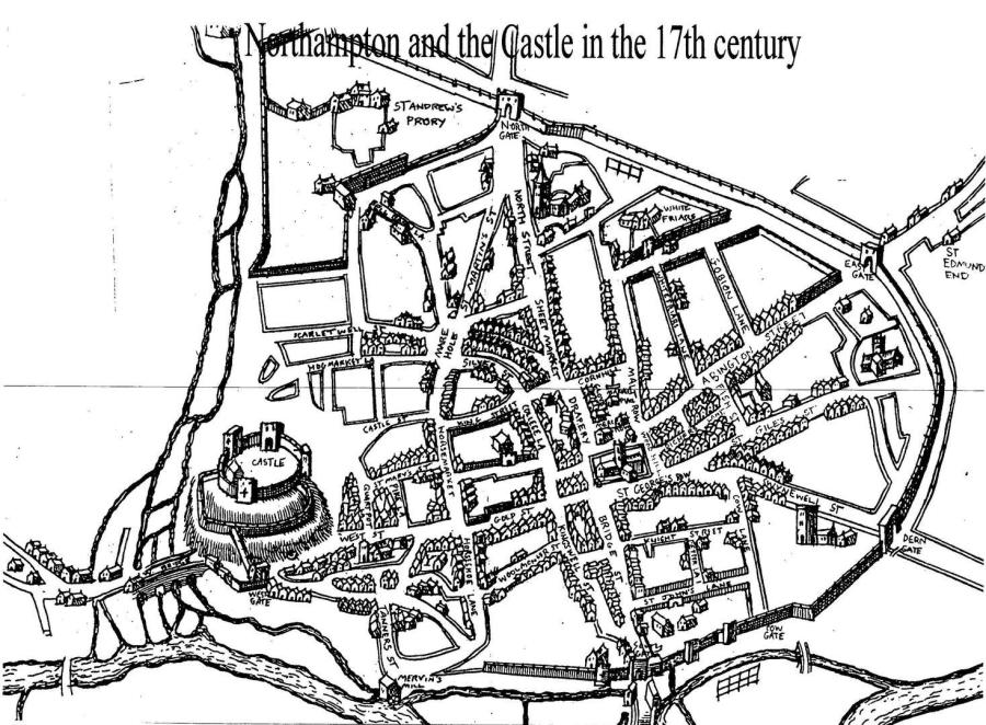
The Boroughs in 1610 is dominated by the Norman Castle which has not yet been destroyed by the vengeful actions of King Charles II This map of the Boroughs was composed by John Speed in 1610. It is part of a much larger map of Northampton There are many interesting points which relate to the origins of the Boroughs as the Medieval and Saxon hub of the town The destruction of the town's walls was yet to take place - an act of vengeance after the restoration of the monarchy since Northampton supported the Parliamentarians in the Civil War. The walls stretched aroun Northampton with five gates - the North Gate is indicated at the end of North Street. The Castle itself is imposing on its familar natural mound. The influence of the religious orders is highlighted by St Andrew's Priory, just outside the Boroughs itself and the names St Marys Street and St Martins Lane recall the important medieval churches which once stood in the area The essentially rural nature of the small town where the sale of animals was a regular event at the frequent fairs is shown by the streets' names - Horse Market, Sheep Street and Hog Market. Mare Hole is an unusual spelling of the Mayorhold - this was alleged to have been the original Market Square of the medieval town The River Nene runs to the west of the Boroughs -its original course which was diverted in 1871 to make space for the marshalling yards of Castle Railway Station. Scarletwell Street runs down to the river, its name unchanged through the centuries
THE BOROUGHS 1831
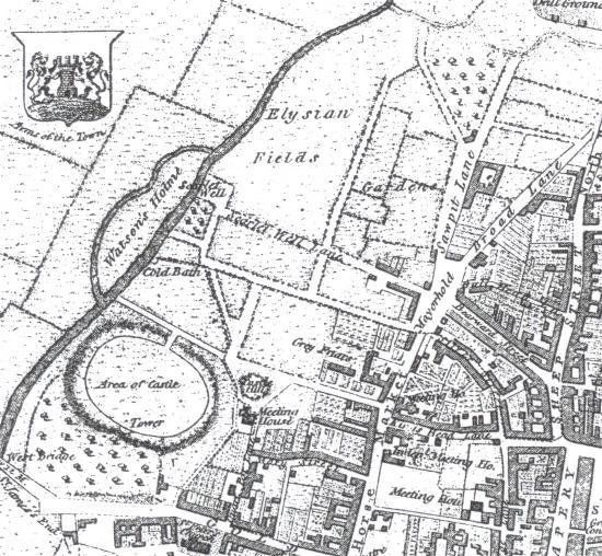
The Boroughs in 1831 still shows the area covered by the Norman Castle which extended over a vast area from its north gate in Fitzroy Street to the Bailey adjoining West Bridge The street layout is familiar. The Mayorhold, allegedly the site of the original Market Square, is clearly marked. Scarletwell Street leads down to the eponyous well famed since Norman times for its waters which were used in the dyeing of red cloth for the Royal Court. Spring Lane has yet to be laid out; at this stage it would have been a rough path to the spring which gushed water downhill to the River Nene. Forty years later this lane would be the location for the new Board School The Saxon defences of the town can be seen following the lines of Bearward Street and Silver Street as they curve round to join up with Scarletwell and Bath Street The Blackfriars, one of the four orders of friars in the town in medieval Northampton, was situated off the Horsemarket but on this map their religious house is incorrectly identified as "Greyfriars". Today on this site stands Blackfriars House which is a modern block of two bedroomed flats; the Cloisters Pocket Park opposite is named after the dwelling of the 13th century religious brotherhood. Everywhere in the Boroughs there are the reminders of a historic past
THE BOROUGHS IN 1851
Northampton's population has increased fourfold from 1801 reaching over 30,000. This is reflected in the number of new streets and houses in the Boroughs

The Boroughs was one of the main areas of population in Northampton at this time. Most of the workers in the footwear industry lived here. A contemporary account describes "Bearward Street, Harding Street, Spring Lane with stagnant, duck-weeded water at its foot; Scarletwell Street, so-called because its well used to be supposed to supply water peculiarly adapted for scarlet-dyeing; and Crispin Street, are the most fashionable quarters of the cordwainers' colony, a part of the town which is almost solely peopled by shoemakers and their purveyors. Neatly built, yet squalid, unfragrant, two floored cottages; roadways splashed with slops, and littered with garbage; dirty children quarrelling, grubbing in the dirt, racing, squealing, squatting on the kerbstone in rows; vixenish women and beery men, in and outside of low "publics", are the salient features of this area.."

This plan of the Boroughs is the first to show Spring Lane; it runs downhill to the River Nene. Much of the land is devoted to orchards and it is evident from the plan that the northern part of the Boroughs was essentially rural at this time. To the south of Scarletwell Street the Boroughs has been built up and many streets have been laid out since the 1831 map.
ST ANDREW'S CHURCH
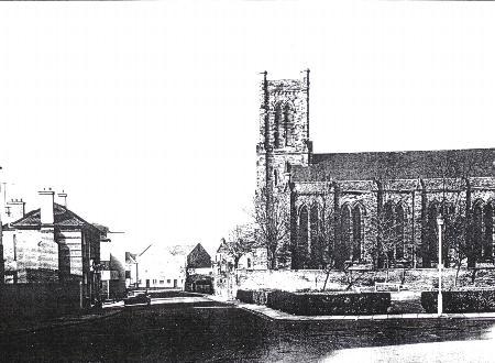
To serve the spiritual needs of the growing population St Andrew's Church (above) was built in 1842 at a cost of £7000 and able to seat 1200 worshippers to serve the growing population. St Katherine's was erected in 1839 to seat a thousand people. It was to be another thirty years before the children of the Boroughs were to be provided with an education in the new Board School in Spring Lane.
CAUGHT IN TIME -PAST VIEWS OF THE BOROUGHS
Some of the earliest streets in the Boroughs have a photographic record. This gives the viewer a fascinating glimpse into the past of this historic part of town
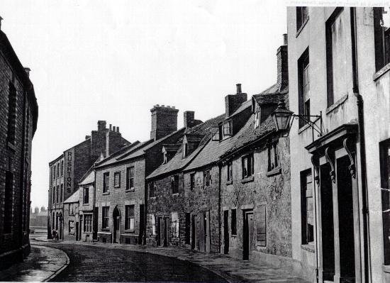
St Mary's Street (above) was the site of the Great Fire of Northampton in 1675; it was here that a woman leaving a pot unattended over a fire was the cause of the subsequent inferno which left the town nearly totally destroyed. The houses pictured here were part of the rebuild of Northampton, mostly dating from the late 17th and early 18th centuries. The house third from the end on the right was St Thomas' Hospital which served as a refuge for the needy. St Mary's Street dates from the 12th century and was named after the medieval Church of the Blessed Virgin, the burial ground of which lay at the end of the street and was used to bury victims of the plague.
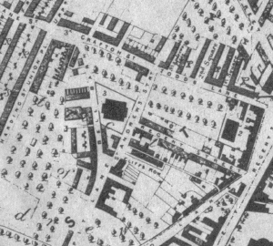
Cliff's Row (above) was a group of houses built at a very early stage in the growth of Northampton. This photograph dates from c 1860s and Cliff's Row is shown (below) on the 1851 map of the town. This is one of the earliest photographs of a street in the Boroughs. When first built, it ws surrounded by open fields and orchards and was accessed from a lane off St Andrew's Street which can be seen in the background.
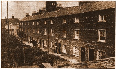
At the bottom of Bath Street was a similar group of three storey houses called Bath Row (below).

This photograph was taken shortly before their demolition in the 1950s. Although not on the 1851 map of Northampton they have appeared by 1871 so presumably another example of the expansion of the Boroughs. Bath Street and Bath Row were named after the Baths available for washing at the bottom of the street. The Boroughs descended to the River Nene to the west and Spring Lane, Scarletwell Street and Bath Street all led to sources of water.
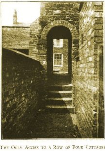
On the 1851 map of Northampton the upper part of Grafton Street was called Todd's Lane; off Todds Lane were several small courts of fairly primitive cottages built to
house the growing influx of factory workers in the footwear industry. The photograph above shows one of these courts which consisted of four cottages, access to which was through a narrow
arch
MAYORHOLD
The Mayorhold had an ancient history dating back to the medieval period. Even the derivation of its name is a mystery. Its early name was often written "Marehole" which would indicate it was a place
where horses were sold. By the 1600s it had become "Mayorhold" and one of the earliest maps of the area clearly shows the medieval Town Hall situated at the top of Scarletwell Street. Was this an
indication of land held by the Mayor of Northampton ?
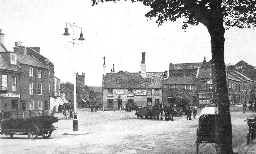
An early photograph of the Mayorhold, 1920s
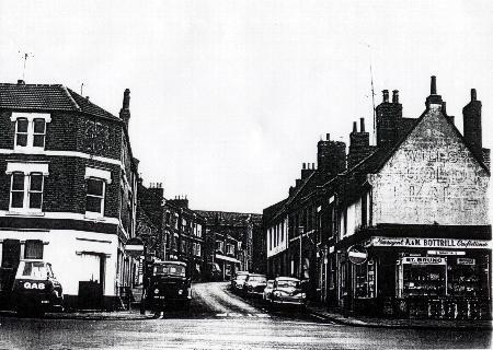
A Boroughs resident remembers "On the Mayorhold there were lots of shops, Bottrill's, the confectioners and newsagents, Smith's Fish and Chips, the Coop Butchers and the Green Dragon pub opposite Perrin's Sweet Shop...it was such a busy part of town and you could get all your shopping there...it was also where all the green buses stopped for travelling out of town"
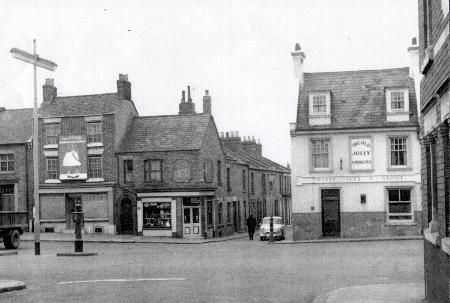
Ray Coles lived in the Boroughs for sixty years and he remembers the area well..."Next to the Old Jolly Smokers up a little alley was the New Model Doss House where the down and outs went...this was a really rough place. In the Doss House, they had cheap beds but for the really hard up they had a rail running along the side of the room and the men had to hold the rail and lean on the wall...yes, that's how they slept...standing up..."

This view of the Mayorhold in 1971 reveals the decimation of this ancient part of Northampton. The Coop grocery store, dated 1919, with its distinctively decorated frontage is due to be demolished later that year. Perrins Sweet Shop still stands on the corner of Bearward Street but not for much longer. The medieval streets, Bearward and Silver, reveal in their layout the early defences of Northampton when the Boroughs was at its heart.